Yet another hotspot? India’s updated political map stirs controversy in Nepal
Both New Delhi and Kathmandu lay claim to a region, known as Kalapani, as part of their countries’ territory.
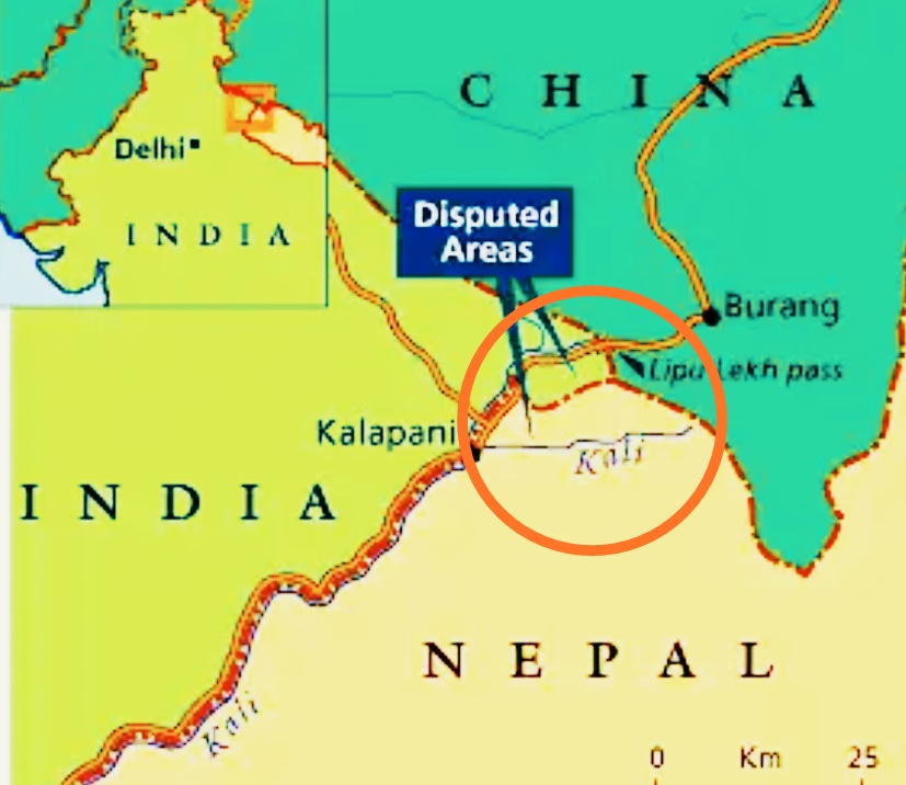
India’s new political map has stirred controversy in Nepal, with both New Delhi and Kathmandu laying claim to a region, known as Kalapani, as part of their countries’ territory.
Members of the opposition parties protested in the capital Kathmandu as well as other parts of the country, accusing India of “illegally occupying” its land.
On Thursday, students linked to the opposition Nepali Congress party protested outside the Indian embassy in Kathmandu, carrying signs that read: “Back Off India”, to protest against the map, bringing back the memory of anti-India protests in the wake of the 2015 border blockade imposed by India.
Nepalese took to social media backing their government’s claim that Kalapani – a 35 square-kilometres (13.5 square-miles) area in Nepal’s far-western region – belonged to the landlocked Himalayan nation with hashtags #BackoffIndia and #Kalapani trending.
Once serving as a trade route between India and what is now southwestern China, the strategic area was “occupied” by India after New Delhi withdrew its border forces following its war with China (in 1962), according to Buddhi Narayan Shrestha, former director general of Nepal’s Survey Department.
Kalapani is the land of Nepal and our party stands firm on this conviction. India is continuously trying to settle this issue but we won’t go back in our claim.
NARAYAN KAJI SHRESTHA, SPOKESMAN OF THE RULING NEPAL COMMUNIST PARTY
“The Nepal government firmly believes that the Kalapani is a part of Nepal,” Nepal’s Ministry of Foreign Affairs said in a statement on Wednesday.
However, a spokesman of India’s Ministry of External Affairs (MEA) claimed the region was part of India.
“Our map accurately depicts the sovereign territory of India. The new map in no manner has revised our boundary with Nepal,” said MEA spokesman Raveesh Kumar.
He reiterated India’s “commitment to find a solution through dialogue in the spirit of our close and friendly bilateral relations”.
“At the same time, both countries should guard against vested interests trying to create differences between our two countries.”
Boundary dispute
Kalapani, which borders the Indian state of Uttarakhand, is also included in Nepal’s official map. Uttarakhand shares an 80km long porous border with Nepal and a 344km border with China.
“Kalapani is the land of Nepal and our party stands firm on this conviction. India is continuously trying to settle this issue but we won’t go back in our claim,” Narayan Kaji Shrestha, a spokesman of the ruling Nepal Communist Party, told Al Jazeera.
India’s Ministry of Home Affairs published an updated map on Sunday after stripping the Indian-administered Kashmir’s special status and splitting the Himalayan region into two federally administered territories in August.
Kathmandu and New Delhi have held a series of talks to resolve the boundary dispute, but Kalapani and the Susta area in southern Nepal remain two major sticking points in negotiations, Gokul Prasad Baskota, Nepal’s communication and information technology minister, told Anadolu news agency.
Nepal also lays claim to Lipulekh Pass close to Kalapani with a T-junction on the trading route between India and China since 2015.
Bipin Adhikari, a constitutional expert, said; “If you go through historical proofs then it is clear that Kalapani is a part of Nepal. It is an illegally occupied territory.”
India and Nepal share an 1,800km (1,118 miles) open border, with thousands of people from both countries crossing the frontier for work and travel.
Relations between the two countries were strained after Nepal blamed India for imposing a border blockade in 2015, which crippled supplies to the landlocked nation.
Many experts in Nepal believe that India has not honoured the 1950 Treaty of Peace and Friendship between the two countries.
With additional reporting by Arun Budhathoki from Kathmandu
- Previous India-Pakistan ‘peace corridor’ opens Sikh temple to tourists
- Next Kazakhstan, Russia discuss rational use of Ural/Zhayik River water resources


